URBAN MAYHEM: 1950 - 1980
This time period marked a era of unprecedented disruptive change to Boston. A trio of mayors; Hynes, Collins, and White, all promised a “New Boston” and set about creating it. Ordinary city life experienced the disasters of urban renewal, busing, ethnic strife, and a spike in crime (Rezendes, 2009). After an era in which little changed, this era seemingly changed everything.
PEOPLEEthnic whites, African-Americans, Puerto Ricans; New Immigration - Asian, Latino, etc.
|
PLACEUrban renewal, highways, parking lots, and office building construction accelerate
|
ECONOMYHealth Care, financial services, high tech
|
PLANNINGModern professional planning; Participatory planning began
|
PEOPLE
Numerous residents left the central city for the suburbs. They were lured by opportunities for single-family homes on spacious plots, open space, and good public schools and pushed by decreasing city services, increasing crime, and racial unrest. Massive highway building and highly subsidized mortgages enabled those aspiring for the suburban life to respond to these factors.
The city’s ethnic makeup also changed dramatically. The majority of the roughly 200,000 people who left the city were white. Because the 1924 law still effectively outlawed immigration, Boston’s foreign-born population continued to declined. While the Immigration Act of 1965 opened the country’s doors, Boston did not become a major destination for foreign immigrants until the late 1970s (O'Connor, 1995). Yet, the city did not lack newcomers. America’s second great migration brought tens of thousands of African-Americans and Puerto Ricans to Boston during these years. Thus, Boston became less white, less foreign, less Jewish, and more African-American and Puerto Rican.
Suburbanizing families vacated neighborhoods, and the expanding African-American population spread into previously white areas. Boston also encountered the social changes experienced nationwide in this period of struggle for civil rights and popular movements against poverty, war, and racism. The most dramatic unrest occurred from 1974-1976 during the implementation of a court-ordered school desegregation plan that paired low-income white and black neighborhoods (Rezendes, 1991).
Suburbanization of people and jobs led to disinvestment in the city. The city struggled to provide adequate services, which led to increased crime and arson in the neighborhoods and downtown. The white middle class had largely forgone downtown and Chinatown as places to shop or visit. With the exception of the financial district, Beacon Hill, and the Back Bay, middle and upper class people avoided the city core during this period of mayhem.
PLACE

Boston's Central Artery construction begins
Boston’s physical changes matched its population changes. These decades are marked by massive demolition of old neighborhoods, a return to downtown building, and rapid transformation away from transit and towards automobile structures. The federal government enabled these large projects through 1949 passage of urban renewal funding programs and the 1956 Interstate Highway Act. By 1968, much of Boston’s downtown had become overrun with parking garages, lots, highways, and modern buildings muddled with fragments of the colonial and the industrial city (O'Connor, 1995). City centers would be left empty once commuters left. The middle class started to leave the old streetcar suburbs and many became the slums.
The North End was truncated and separated from downtown by the construction of the Central Artery elevated highway in 1956 (Tsipis, 2000). Many cleared areas in the South End, Roxbury, and other neighborhoods were replaced with housing projects. Residents responded to the destruction by beginning to organize and plan for themselves.
During this period, the automobile came to rule the city. The transportation network expanded with construction of the Central Artery, the Southeast Expressway, the Turnpike extension, I-93, Route 3, Route 24, the Tobin Bridge, and the Callahan Tunnel. Other forms of transit within the city suffered in the shift. Ferry service to East Boston ended. Trolley lines closed almost everywhere, but were replaced by buses.
Boston’s waterfront also changed dramatically. Its necessity as a port had already been succeeded by Boston’s shrinking port trade and by the construction of more modern ports in Charlestown and South Boston. By the end of this period, the old waterfront had effectively vanished. Most of the old waterfront and warehouses were demolished and replaced by parking lots.
ECONOMY
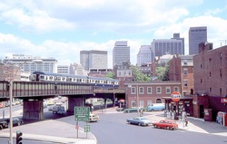
Charles Circle, 1978
Not only did Boston’s population suburbanize, but jobs did also. Boston’s economy had slumped for decades, but this period marked the beginnings of recovery. The core city’s economy turned around when Boston’s financial sector emerged as a worldwide leader in mutual funds, insurance products, high tech industries, and health care. The growth of these firms enabled the construction of new towers downtown and in the Back Bay (Boston Redevelopment Authority 2013).
PLANNING
In the face of turmoil and suburbanization, planners and municipal leaders scrambled to roll out efforts aimed at revitalizing the city. They called for slum clearance, urban renewal, and highway construction. The administrations that ruled during these decades concentrated on downtown and laid out plans for a “New Boston.” Massive downtown building, urban renewal, and highway projects took priority. As a result, a ten-year comprehensive plan, a new zoning ordinance, and the city’s first capital budget was created (O'Connor, 1995).
